 |
| Sign, Hobbucks Nature Reserve, Arnold |
'Above all, do not lose your desire to walk. Every day I walk myself into a state of well-being and walk away from every illness. I have walked myself into my best thoughts, and I know of no thought so burdensome that one cannot walk away from it.'
Soren Kierkegaard
Killisick is about three miles from my humble abode, as the crow flies, but until recently its existence had never troubled mine. I lived, gentle reader, in happy ignorance of whatever heady delights it may or may not have had to offer.
That changed recently when I chose Nottingham City Transport's number 58 Lime Line bus service from the city centre to Killisick as a test route for a potential new project calculated to reinvigorate my appreciation of, and engagement with, the less celebrated parts of Greater Nottingham.
The idea? Travel to the final stop of a particular NCT bus route, disembark, have a look around and report back.
Simple as that.
A salve for the existential dread that lives rent free inside my head.
Yesterday, I embarked on the inaugural journey...
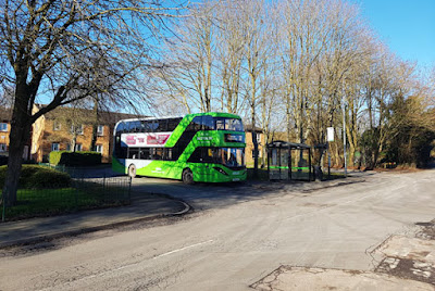
It's early afternoon when the 58 drops me off at its last stop - Gleneagles Drive. It could be argued that, technically speaking, this stop is not the actual end of the line, as the bus subsequently trundles on a few yards further to a turning circle, where it picks up its first passengers for the return journey. However, this is psychogeographical nit-picking, and I do not, in any case, want to take the risk of annoying the driver by doggedly staying on until the turning circle, because, as any fule kno, NCT drivers are generally already annoyed enough as it is.
 |
| The 58 prepares for its journey back to civilisation |
The area known as Killisick, which seems to consist mainly, if not entirely, of the post-war Killisick Estate, is part of the great urban sprawl of Arnold - a place I've never really been able to develop any great affection for - lying to the northeast of the latter's centre.
It's easy to lose track of the topography of an area when it is more-or-less entirely covered in houses and tarmac, but we're most definitely up in the hills here. Killisick has a remote feel to it, even though it's no more than four or five miles from central Nottingham.
As I wander past the recreation ground, community centre and defunct Baptist church on this sunny Saturday afternoon, I'm largely untroubled by the presence of my fellow man.
The sole users of the recreation ground are a father and son playing football, the community centre is shut and the former church building is awaiting demolition, all of which speaks volumes.
 |
| The former Beacon Baptist Church |
A brief foray into the heart of the housing estate is uninspiring, so I head for the nearby Hobbucks Nature Reserve. An incongruous mini basketball court ruins the initial sense of escape somewhat, but further ingress reveals a rugged, expansive site with possibilities for onward exploration of the surrounding area. This is very much edgelands territory.
After passing a trig point and entering a wooded area, I eventually emerge, somewhat disorientated, into an open space that has tremendous views out to the west and south-west. A sturdy plaque next to two benches shows the locations of various landmarks, but the sun is in my eyes and the only one I can positively identify is Ratcliffe-on-Soar Power Station.
 |
| Trig happy |
As I raise my phone with one hand to take a photo of the impressive scene before me, simultaneously using my other hand to block the glare of the sun, I forget that I've been holding a cheese sandwich, which promptly falls to the floor. I can't bring myself to apply the five-second rule, but a passing dog goes into paroxysms of olfactory joy courtesy of the jettisoned cheese, so at least someone has benefitted from my misfortune.
Long stretches of tall metal fencing along one side of the reserve alert me to the presence of Dorket Head Quarry. I begin to follow the route of a bridleway, and there are tantalising glimpses of parts of the quarry through the fencing before broader views open up as I join a footpath and gain higher ground.
Leaving the epic views of the quarry behind me, I make my way into a woodland area that, a sign amusingly informs me, was 'planted with children from Richard Bonington Primary School'.
Alas, shortly afterwards, the bucolic spell is broken as the footpath I'm following leads out onto Mapperley Plains, with its seemingly endless procession of cars. A short distance away, on the other side of the road, the Travellers' Rest provides the opportunity for a little liquid refreshment before I make my way home.
It's been an invigorating walk, and a timely reminder that interest and beauty can be found in the most unexpected places.
Now where did I put that bus map?


More trig points please! I love the idea of them yet, despite having lived with an NG postcode most of my adult life, I’d be hard pressed to point you in the direction of a single one.
ReplyDeleteHmmm, challenge accepted! https://jdconey.github.io/run/trigmap
DeleteThe Travellers Rest has distinct memories for me from the late 60s, as do Catfoot Lane, Lambley Dumble and Fox Covert. Pushbike exploration from Mapperley as a young teenager...
ReplyDeleteI'm definitely aiming to spend more time exploring that area. My dad grew up in Woodborough, so I feel it's a way of reconnecting with him.
Delete